Wednesday, October 21, 2009

Baby Sea Turtles Released


Thanks to my friend Steve Chism, amateur geologist, local naturalist, author and puppy lover, I have photos of the recent baby sea turtle release in front of the Palmas de Cortez hotel in Los Barriles. (Steve is also an official, Mexican certified turtle research assistant) He participated in the release in which a few hundred newly hatched baby sea turtles were released into the Sea of Cortez. This event serves the dual purpose of ensuring that a known number of sea turtles survive from the nest to the water and to raise public awareness of sea turtle nesting habits and how we can help ensure their survival. The greatest danger in the life-cycle of sea turtles is from the point the eggs are laid to re-entry into the ocean. On the shore, the mother sea turtles are exposed to predatory animals and poachers as they go through the ritual of depositing their eggs. The eggs are in danger of being eaten by a large number of predators from crabs to foxes and the nests being compressed by motor vehicles. Then during the hatch and return to the sea, the baby sea turtles are exposed to an even larger group of predators when you add birds and shore fish to the list.
If you are in the los Cabos area, ask around and see if you can find out where a baby sea turtle release will take place. It will be well worth your time to attend. Take your kids or borrow some; they'll love it.

Rick Outa Here

Rick is still attempting to weaken and dodge the Baja. There's still the possibility that he could stall over the Sea of Cortez, pick up steam again and follow the warmer water to the North. Which is basically what happened 3 years ago with hurricane John. As John approached San Jose del Cabo, it slowed, turned East and followed the warmer water to landfall almost RIGHT ON TOP OF US! By the way,San Jose hasn't been clobbered in years. Maybe they really do have the hurricane deflecting machine.

With a little luck, this will be the last storm of the year. And good riddance to them.

Saturday, October 17, 2009

Tropical Storm Rick


Every year around the first of October, we Bajanians get restless for the "all clear" signal. This year we had a close call when Jimena skirted us on the Pacific side and did her damage to our compadres to the North. We've had plenty of rain but not enough to cause flooding and do us some damage. So for a week or so, we've been living under the delusion that the worst is over. HA!

It looks like any hope we had of easing into fall is now being threatened. Tropical storm Rick is heading toward us with the promise of lots of rain in a short time and possible winds of the high-velocity type. (See above illustration.)

We locals are in high hopes the storm will start losing strength when it passes over cooler water as it approaches Los Cabos. This idea is reinforced by the weather folks over at NOAA. Here's an excerpt from the National Hurricane Center:

RICK IS STILL INTENSIFYING...WITH THE 10 NM WIDE EYE BECOMING BETTER DEFINED AND THE EYEWALL CLOUD TOPS COOLING DURING THE PAST FEW HOURS. SATELLITE INTENSITY ESTIMATES FROM TAFB AND SAB WERE 127 KT AT 18Z...SO THE INITIAL INTENSITY IS INCREASED TO 130 KT BASED ON THIS AND THE SUBSEQUENT INCREASE IN ORGANIZATION. THE CIRRUS OUTFLOW IS GOOD TO EXCELLENT IN ALL DIRECTIONS. QUIKSCAT DATA NEAR 14Z INDICATED THAT RICK IS GROWING LARGER IN SIZE...AND THE WIND RADII HAVE BEEN EXPANDED ACCORDINGLY.

RICK SHOULD REMAIN IN A NEARLY-IDEAL ENVIRONMENT OF LIGHT VERTICAL WIND SHEAR AND OVER WARM SEA SURFACE TEMPERATURES FOR THE NEXT 18 HRS OR SO. THUS...IT SHOULD CONTINUE TO INTENSIFY UNTIL AN EYEWALL REPLACEMENT CYCLE OCCURS OR IT REACHES THE MAXIMUM POTENTIAL INTENSITY FOR THAT AREA. BASED ON THIS...THE INTENSITY FORECAST CALLS FOR THE HURRICANE TO REACH CATEGORY FIVE STATUS IN ABOUT 12 HRS IN AGREEMENT WITH THE SHIPS MODEL. AFTER THAT...GRADUALLY COOLING SSTS AND GRADUALLY INCREASING SHEAR SHOULD START A STEADY WEAKENING TREND FOR THE REMAINDER OF THE FORECAST PERIOD...WITH LAND INTERACTION ALSO BECOMING A FACTOR DURING THE 96-120 HR PERIOD. EYEWALL REPLACEMENT CYCLES COULD CAUSE FLUCTUATIONS IN INTENSITY SUPERIMPOSED ON THE GENERAL TREND INDICATED IN THE FORECAST.

I'll post updates at irregular, un-predetermined intervals.

Thursday, October 15, 2009

After The Rain

The storm didn't amount to much but we got a lot of well-needed rain in absorbable doses. (is "absorbable" a word? IS NOW.) We'll be green here for several months and the transition to dryness is very gradual. Sometimes we get some rain in January or February that will prolong the change to dryness.

The top photo was taken yesterday. I'm standing next to the highway above Hotel Rancho Buena Vista; Los Barriles is in the distance.

The bottom photo was taken in the spring of about 1971 from the beach just a short walk from Hotel Rancho Buena Vista and looking towards Los Barriles.

Tuesday, October 13, 2009

Tropical Storm Patricia

Looks like tropical storm Patricia is going to skirt the Cabo/San Jose area on her way out to open water in the Pacific. That's fine with me. Right now we're having good rain: no flooding or damage and no wind. The ground is soaking it all up and the aquifer is is being replenished. It's a beautiful thing.

Monday, October 5, 2009

Arriving Home

Just South of Santa Rosalia is the orphanage I mentioned earlier. A friend had asked us to deliver some items and we planned on visiting with our friends Doug and Diane who oversee the orphanage. Diane was very sick with the flu so we didn't get to see them. Here is the lady of the house and one of their young charges who swore to me she wasn't skipping school.

Everything is green from the recent rain storms. We were going to drive over the mountains from a cutoff just North of Loreto that comes out at La Purisima but we didn't this time because of the recent storm; the road was most likely in poor shape. The mountain road probably isn't a shortcut but when you get to La Purisima, the road is paved again. La Purisima has a river that has water year around and there are hundreds of palms growing there. After passing through La Purisima, you drive south to Insurgentes, on to Constitucion and then La Paz.


We evidently just missed a dandy rainstorm that hit La Paz. As you can see in the video, there was lots of water left over. Every low spot on the highway had standing water. The water was running enough to wash out some holes in the road and the holes were well marked by the cars that had fallen into them.

We got home to Buena Vista around 9 in the evening.

The trip was 2 days. That's too fast to enjoy but we had a commitment at home that had somehow moved forward a few days. Taking 3 days instead of 2 is much more relaxing and allows for a few hours of stops here and there. If you plan to come down via Highway One, try to take 3 or more days. Do your homework on the internet and find out what's here to be seen or to do. If you're coming between December and February, pre-book a whale-watching tour. Find out where the cave paintings are and visit one. Or you could stop at one of the wineries. There are a couple to choose from.

Saludos!

Friday, October 2, 2009

Still Driving South On The Baja

Something I forgot to mention is that there are military stops scattered here and there. If you are traveling south, they rarely stop cars with US plates. I guess they figure we're not smuggling pot INTO Mexico. If they stop you, they will ask where you are travelling from. Then where are you going. That's about it. I've always been treated with courtesy at these stops. Remember: by and large they are simply doing their job.

When you return North, they are more concerned with US plated vehicles. You might get searched for guns and drugs. Generally speaking these soldiers are lightly trained young men who are living in very basic conditions with very little entertainment outside of searching cars. It's always a good idea to carry something to give the kids. Believe me when I tell you, they will appreciate it. I handed out bottles of water one trip and Reece's peanut butter cups another time. One trip North I had a backpack in the back of a trailer and inside, I had somehow left a cleaning kit for a .22 caliber rifle. At the last stop before Tijuana, a young soldier found it. He asked me what it was. I told him and asked if he had a .22 rifle. He said yes so I gave him the kit. I've never seen a half-dozen soldiers lose interest in a car inspection so fast. The other boys were all huddled around the lucky one checking out his prize. The thing to remember is don't be afraid or worried. Normally they just ask a few questions and send you on your way.

Meanwhile, back at the journey,
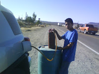
I already told you about the long drive without gas between El Rosario and Guerrero Negro. If you get in a jam you can buy gas at Cataviña on the side of the road. This guy with the drums must really get a kick out of us dummies that can't do the math. Oh yeah, I said "us dummies." I've bought gas from him 2 or 3 times.

There is a section of road in the mountains I think between Cataviña and Gurrero Negro that has new pavement. They have not replaced all the signs yet. You'll recognize it because of the lack of curve signs. There are 2 curves that are nasty. I went into one at night doing 50 or so and nearly didn't come out the other side. So if you can't see how sharp the curve is, fear for your life.

You will drive past a gas station (or into it maybe) then through a military base just North of Guerrero Negro and soon after is an agriculture stop. They'll take any fruits or veggies from you and ask for 10 pesos "cooperacion" (like a donation) and then you drive across a pipe that sprays something, presumably bug killer, up under your car. As soon as you clear the sprayer thing, pull over and get your tourist visa stamped at the little trailer.

Next is Guerrero Negro but there's not much there if you're not going whale watching or need gas or a hotel. It's always like an Oregon coastal town: overcast, windy and cold. They have salt production and whales, not much more.
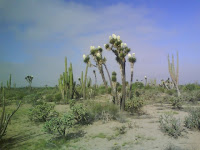
It's about 130 miles to Santa Rosalia from Guerrero Negro. There's gas at Vizcaino and San Ignacio. The first few miles out of G.N. is kind of blah then there's a yucca forest with huge yuccas. It's really green now because of the storm that just blew through. Then you pass San Ignacio, then arrive at Santa Rosalia. If you are going to get gas, buy it at one of the first 3 or so stations. The last one in town is a notorious ripoff. Bajanians with more than a few trips under their belts all have stories about the various tricks they use to rob or short-change you there. Santa Roselia still has quite a bit of un-repaired hurricane damage but all services are restored and traffic-wise, everything is normal. 
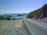
There's some great photo ops along the coast as you travel south past Mulege and Loreto and on through the mountains. Stop when you see something good. You have time: don't get in the "we have to get there" mode. Promise?

Next: Arriving home.

Apture